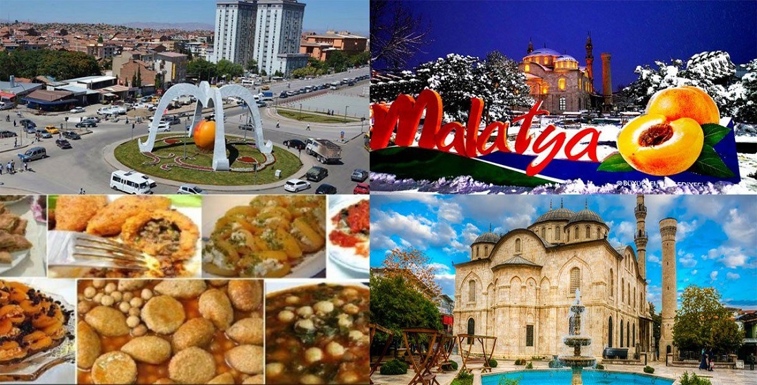
The pearl of Eastern Anatolia, Malatya, as one of the 30 metropolitan provinces of our country, is located in the Upper Euphrates part of Eastern Anatolia. Malatya, which draws attention with its natural beauties and magnificent historical heritages and is famous for its apricots, is spread over an area of 12,313 km² in total.
While the population of Malatya is 808,692 according to the census made in 2021, how many districts of Malatya? In response to your question; It has a total of 13 districts and 718 neighborhoods, 2 of which are in the center. The districts of Malatya are as follows;
Malatya central districts;
•
Battal Ghazi
• Yesilyurt
Malatya other districts;
• Akcadag
• Arguvan
• Arapgir
• Darende
• Doğanyol
• Doğanşehir
• Hekimhan
• Use
•
Castle
• Pütürge
• Yazihan
Battal Ghazi
Battalgazi, one of the central districts of Malatya, is one of the most crowded Malatya districts with an area of 906,493 km2 and a total population of 304,750. Battalgazi, which attracts attention with its historical structure and natural beauties, consists of 103 neighborhoods. Although its economy is based on agriculture, it is located in the Malatya Plain and the geographical structure of the district is generally flat.
Yesilyurt
Yeşilyurt, which is the largest district of Malatya in terms of population and also one of the two central districts of Malatya, has a mountainous land, with a surface area of 1.025,701 km2 and a total population of 337,049. Although it comes to the fore with its natural beauties, it is also very rich in terms of historical artifacts.
Akcadag
With a population of 28,283, Akçadağ has a surface area of 1,146,665 km2. The northeastern and southern parts of Akçadağ, which has the Nurhak Mountains in the west, are flat. While Ebeler Stream and Sultansuyu are the rivers located here, its economy is based on agriculture and animal husbandry, but fruit growing is highly developed here.
Arguvan
Arguvan, as another district of Malatya, is the district of Malatya with the least population today. This district with a population of 7,105 was established on an area of 1,111.03 km2. Agriculture and Livestock, especially transhumance determine the economy of this place. It is a place that stands out with its natural beauties.
Arapgir
With an area of 1,020,665 km2, Arapgir has a total population of 10,119. The district center is located in the Kozlukçayı Valley, and Sarıçiçek plateau and the Euphrates River and Kozlukçayı streams are located here. While a part of the Keban Dam is also within the borders of this district, immigration from Arapgir district is generally experienced due to its infertile soil.
in dare
Darende, which is a very old settlement with many historical beauties dating back to Eti and Sumerians, has an economy based on agriculture. The largest district of Malatya is Darende in terms of surface area. The total population of Darende is 24,923 and its total surface area is 1,480,163 km2.
Doganyol
Doğanyol is the district of Malatya, which has the least population and the smallest surface area. Doğanyol, as an undeveloped and small district, has a population of 3,794, and its surface area is 179,727 km2.
Dogansehir
The total population of Doğanşehir is 38,136 people. Doğanşehir, which has a surface area of 1,389,688 km2, is located on the Malatya-Kahramanmaraş railway, although it is approximately 60 km away from the city center.
Pütürge
While Pütürge is a district with a population of 12,976 according to the census made in 2022, its total surface area is 1,063,066 km2. As a small and undeveloped district, it is located on a mountainous terrain.